
Fájl:Map of 1746. Longitudines numeratae a Primo Meridiano per Insula Ferri.jpg
Map_of_1746._Longitudines_numeratae_a_Primo_Meridiano_per_Insula_Ferri.jpg (800 × 300 képpont, fájlméret: 104 KB, MIME-típus: image/jpeg)
|
Ez a fájl a Wikimedia Commonsból származik. Az alább látható leírás az ottani dokumentációjának másolata. A Commons projekt szabad licencű kép- és multimédiatár. Segíts te is az építésében! |
Összefoglaló
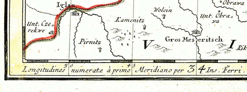
Larger towns:
On the lowest edge of the map - Latin message:
- Longitudines numeratæ à primo Meridiano per Insula Ferri - meaning the prime meridian for this map is El Hierro Island (known as Ferro as well)
Większe miejscowości:
Na samym dole przy krawędzi mapy łacińska informacja:
- Longitudines numeratæ à primo Meridiano per Insula Ferri - oznaczająca, że południkiem odniesienia dla tej mapy jest południk wyspy El Hierro (znanej też jako Ferro)
Licenc
|
Ez egy kétdimenziós, közkincs mű hű fényképe. Maga a mű a következő okból számít közkincsnek:
A Wikimédia Alapítvány hivatalos álláspontja szerint „kétdimenziós közkincs művek hű reprodukciói közkincsnek számítanak”. Ez a fénykép ezért szintén közkincsnek számít. Más jogrendszerekben ennek a műnek az újrafelhasználása korlátozott lehet; lásd a Commons:Reuse of PD-Art photographs lapot a részletekért. {{PD-Art}} template without license parameter: please specify why the underlying work is public domain in both the source country and the United States
(Usage: {{PD-Art|1=|deathyear=''year of author's death''|country=''source country''}}, where parameter 1= can be PD-old-auto, PD-old-auto-expired, PD-old-auto-1996, PD-old-100 or similar. See Commons:Multi-license copyright tags for more information.) | ||||
Fájltörténet
Kattints egy időpontra, hogy a fájl akkori állapotát láthasd.
| Dátum/idő | Bélyegkép | Felbontás | Feltöltő | Megjegyzés | |
|---|---|---|---|---|---|
| aktuális | 2005. december 4., 22:21 | 800 × 300 (104 KB) | Julo | {{en}} Detail of the map of Silesia drawn in 1746. *Iglau = moravian city en:JihlavaJihlava *Gros Meseritsch = moravian town Velké Meziříčí On the lowest edge of the |
Fájlhasználat
Az alábbi lap használja ezt a fájlt:
Globális fájlhasználat
A következő wikik használják ezt a fájlt:
- Használata itt: az.wikipedia.org
- Használata itt: en.wikipedia.org
- Használata itt: eo.wikipedia.org
- Használata itt: es.wikipedia.org
- Használata itt: fr.wikipedia.org
- Használata itt: it.wikipedia.org
- Használata itt: ja.wikipedia.org
- Használata itt: la.wikipedia.org
- Használata itt: nl.wikipedia.org
- Használata itt: pl.wikipedia.org
- Használata itt: sl.wikipedia.org
- Használata itt: sr.wikipedia.org